|
Five backpacking trips into the mountains
 |
Zach Urness/Daily Courier
|
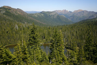
The mountains of Southern Oregon and Northern California are filled with great backpacking destinations. Here are five to try. o o o oBy Zach Urness of the Daily CourierThe mountains are calling, and I must go.Outdoor writer John Muir penned those celebrated words more than 100 years ago, and if I had to guess, I’d say he wrote it in June. There’s something magnetic about the mountains this time of year, as the sun begins opening trailheads trapped beneath snow since November. The impulse to grab a backpack and go crashing into the woods becomes impossible to resist. The mountains are calling, and I must go. There’s no universal metric for ranking the best backcountry trips into the mountains — people have different tastes — but through the years I’ve decided on three important factors. The first, of course, is natural beauty. How quickly does the trail or camping spot inspire you to take out your camera? The second is something I call the “wilderness experience.” Does it feel as though you’ve escaped all remnants of civilization, or is the trail as crowded as a shopping mall? The third and final measurement is harder to define, but I call it the “icing on the cake” factor. This takes into account a spot’s availability of fishing, mountain climbing, swimming, or any other activity a person might enjoy in the outdoors. During the past week, I took time to score my favorite spots within roughly 80 miles of Grants Pass on a 1-to-10 scale. Below, I’ve included the places that finished in the top five. I haven’t been to every single backcountry destination in Southern Oregon and Northern California’s vast mountain ranges because that would take a lifetime. My goal in compiling this list is to give readers a broad cross section of outstanding places they might enjoy exploring this summer. You can find detailed information for each of these places listed below. 1) Raspberry Lake/Devil’s Punchbowl Located just south of the Oregon/California border, these immaculate mountain lakes — they are about 11.2 miles apart — highlight a backpacking Shangri-La among the immense, craggy peaks of the Siskiyou Mountains. There are wildflower valleys and beautiful creeks — including the east fork of the Illinois River — which carve out an area difficult to reach and still relatively unknown to the masses. Devil’s Punchbowl is a small emerald lake encircled by massive silver cliffs, while Raspberry Lake sits comfortably at the base of surrounding peaks. Devil’s Punchbowl is the more spectacular of the two. Raspberry Lake has better camping and fishing, along with a close proximity to Preston Peak, a fun Class 3 scramble climb toward its 7,309-foot summit. Location — Siskiyou Wilderness, between Cave Junction and Crescent City, Calif. Overall beauty (out of 10) — 9 Wilderness experience — 9 Icing on the cake — 8.5 Total — 26.5 2) Illinois River’s Pine Flat Nestled among the dry, wild Kalmiopsis Wilderness, this camping spot is a lush oasis along the the Illinois River. The surrounding forest is filled with exotic wildflowers and an almost desert-like landscape — in part because the 2002 Biscuit Fire scorched this area — but Pine Flat is lush, grassy and surrounded by mountains. There are places to camp both in the sun and below the shade of trees. There are cool turquoise pools of water excellent for swimming during the summer and areas to fish. The Illinois River trail, which leads to Pine Flat, follows a spectacular canyon carved out by one of the state’s most beautiful rivers. Location — Kalmiopsis Wilderness, near Selma Overall beauty — 8.5 Wilderness experience — 9 Icing on the cake — 7.5 Total — 25 3) Azalea/Lonesome Lake This fantastic pair of lakes in the Red Buttes Wilderness offers a scenic hike around Phantom Meadow, atop mountain passes and across the Oregon/California border. The lake itself has well-established campsites and hungry brown trout for anglers. Lonesome Lake — and how can you not love that name? — is a 1.5- to 2-mile hike from Azalea. The best part of Lonesome? Jumping over the lake’s mountain Azaleas and into the deep, cool water from a rock outcropping. Mosquitos are a slight annoyance, but not a huge problem. Location — Red Buttes Wilderness, near Applegate Overall beauty — 8 Wilderness experience — 8 Icing on the cake — 8.5 Total — 24.5 4) Blue Canyon Basin This collection of lakes is among the most beautiful, and most popular, in Southern Oregon. The Blue Canyon Trail takes hikes through a collection of scenic lakes. The crown jewel is Blue Lake, which is surrounded by meadows and backed by the large cliff. During the height of summer the area’s mosquitos are so large and aggressive they’ve been known to lift backpackers up in the air and drop them in the closest lakes. (That is not actually true, but can seem plausible.) Because of these bugs and the high volume of people, the best time to visit is autumn. Location — Sky Lakes Wilderness, near Butte Falls Overall beauty — 8.5 Wilderness experience — 5.5 Icing on the cake — 7.5 Total — 21.5 5) Redwood’s Little Bald Hills This trail, that begins in Jedediah Smith Redwoods State Park, is less of a mountain backpacking adventure than the other trips, but it’s still phenomenally beautiful and underrated destination among the world’s most famous trees. The trail begins among the old-growth redwoods — the famous Stout Grove is just down the road — and moves into conifer forest, prairie lands, second-growth redwoods and a mixture of Douglas fir, western red and port oxford cedar trees. There’s a campsite 3.5 miles up the trail flush with picnic tables and fire rings, but if you keep going, you can reach the Smith River. Location — Jedediah Smith Redwoods State Park, near Crescent City, Calif. Overall beauty — 8 Wilderness experience — 5 Icing on the cake — 5 Total — 18 DETAILS Devil’s Punchbowl Zach’s trip rating (out of 5): 4.5 Location: Between Grants Pass, Ore. and Crescent City, Calif. Accessible: Late June to November Distance: 13 miles round-trip Difficulty: Hard Camping: Yes Directions: From Grants Pass, Ore. drive Redwood Highway 199 south past the Siskiyou Summit tunnel for 53 miles. Once you pass the tunnel, turn left on Little Jones Creek Road. Stay on paved road 10 miles. Turn left at gravel Road 16N02 and follow it for 4.2 miles to trailhead. Quick hit: This sometimes tough trail leads to one of the most spectacular lakes in the Siskiyou Mountains. The trail is very tough in some places. There is a mountain lake below the true Devil's Punchbowl. There are camping spots near the shoreline. Raspberry Lake/Young's Valley Trail Zach’s trip rating (out of 5): 5 Location: Between Grants Pass, Ore. and Crescent City, Calif. Accessible: Late June to November Distance: 13 miles round-trip Difficulty: Hard Camping: Yes Directions to Young's Valley TH (5400 feet): From Grants Pass, drive south on Redwood Highway 199 past the Siskiyou Summit tunnel for 48 miles. Once you pass the tunnel, drive 3.5 more miles and turn left at Knopki Creek Road (18N07). Follow the road 14 miles to a T-Junction and turn right for one more mile to trailhead. Quick hit: One of the most beautiful lakes in the Siskiyou Mountains is reached on a fairly tough but pleasant trail that leads through the fantastic Young’s Valley. There are camping spots around the lake. Illinois River Trail (Pine Flat) Zach’s trip rating (out of 5): 4 Location: Near Cave Junction/Selma, Ore. Accessible: Year-round Distance: 21 miles round-trip to Bald Mountain; 11 miles round-trip to Pine Flat Difficulty: Very difficult to Bald Mountain; Moderate to Pine Flat Camping: Yes Directions: From Grants Pass, drive south on Redwood Highway 199 to Selma and a flashing yellow light. Turn right on Illinois River Road 4103 and follow it 18.6 miles to its end. The final stretch of the road is very rough. Quick hit: A dry, beautiful trail through some of Southern Oregon’s wildest country, following the scenic Illinois River. Pine Flat is one of the area’s best backcountry camping spots while the trail to Bald Mountain is one of the toughest. Azalea Lake Zach’s trip rating (out of 5): 4 Location: Near Grants Pass/Applegate, Ore. Accessible: Late June to November Distance: 14 miles round-trip to Azalea Lake; 20 miles round-trip to Lonesome Lake Difficulty: Hard Camping: Yes Directions: From Grants Pass, travel south on Highway 238 for 18 miles to green steel bridge before Applegate. Turn south onto Thompson Creek Road for 11.9 miles. Proceed through the intersection for 2.8 miles on gravel road. Turn right, cross a bridge (there may be signs that read “fir glade”) and fork immediately left onto Road 1030 for 5.1 miles. Then turn left onto Road 400 for 4.7 miles (it becomes Road 1040). Fork right onto rough Road 800 for 0.6 of a mile and stay left into small parking lot. Trail begins at Fir Glade Trailhead. Quick hit: This tough hike takes you across the Oregon/California border, along Phantom Meadow, and over the top of two mountains passes before dropping into Azalea Lake. Lonesome Lake requires another 1.5 to 2 mile hike south. Blue Canyon Basin Zach’s trip rating (out of 5): 4 Location: Near Butte Falls, Ore. Accessible: Late June to November Distance: 4.6 miles round-trip to Blue Lake; 11 miles round-trip to Island Lake Difficulty: Easy/moderate Camping: 100 feet from lakeshores Directions: From Butte Falls, turn left onto Butte Falls-Prospect road and follow it for nine miles. Then turn right onto Lodgepole Road 34 for 8.5 miles. Turn right at Road 37 for 7.4 miles as it becomes gravel. Turn right on Road 3770 for 5.3 miles to large parking area. Quick hit: Blue Canyon trail heads out through multiple mountain lakes in the Sky Lakes Wilderness. Little Bald Hills Zach’s trip rating (out of 5): 3 Location: Near Crescent City, Calif. Accessible: Year-round Distance: 7 miles round-trip Difficulty: Easy/moderate Camping: Yes Directions: From Grants Pass, follow Highway 199 south for 70 miles. Turn left after crossing Smith River onto South Fork Road and follow pointers onto Howland Hill Road. Trailhead along left side of rough, beautiful road though the Redwoods. Quick hit: A trail through Redwoods to a nice campsite in Jedediah Smith Redwoods State Park
|