|
Middle Fork of Smith features rapids, glass-clear water
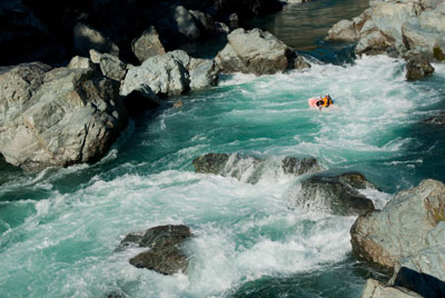 |
Photo by Darin McQuoid
Nate Barnard runs the Middle Fork Gorge of the Smith River. |
The Middle Fork of the Smith River is a stream that thousands of people driving down Highway 199 dream about running. There are some easy and very difficult floats, but actually getting on the river does provide some obstacles. For links to the best sources of information, see below.o o oBy Zach Urness of the Daily CourierEach day during winter, spring and early summer, the Middle Fork of the Smith River becomes a tantalizing distraction for thousands of drivers heading down Highway 199 between Grants Pass and Crescent City, Calif.The view of a sapphire ribbon of water slicing through silver canyons and below waterfalls makes it nearly impossible to keep your eyes locked on the road.More than once, I've come perilously close to drifting into the wrong lane or driving off the road altogether as I craned my neck for a better view.And each time I'd catch a glimpse of that crystal-clear water — some of the purest in the world — the same thought would echo through my brain:“Man, I really wish I was floating that river.”But there’s a problem.All three forks of the Smith — the North, Middle and South — only are runnable when the weather is typically cold and rainy, from about December to mid-May.The water is both frigid and erratic, rising dangerously high in an instant before dropping to almost nothing. And, as just one glance from Highway 199 confirms, the river is home to plenty of do-not-screw-around Class IV+ rapids.Sounds inviting, huh?During the past two years, I’ve put plenty of effort into figuring out how to run a coherent trip on a river that can be as vexing as trigonometry.Not a single outfitter offers guided floats, and the best information is often gained by just talking to locals such as “Bearfoot” Brad Camden (707-457-3365) and the Smith River Alliances’ Grant Werschkull (707-458-3586).The trips haven’t always gone smoothly. Indeed, they’ve ranged from almost perfect to near-calamity. The only common theme when it comes to running the Smith is that it's never, ever, boring.THE MELLOW FLOATThe Outdoors Gal gave me a final look of skepticism and asked one last question before she stepped into the 12-foot Avon raft.“So you're sure about this, right?” she said, tightening the straps of her wetsuit. “Because this water looks really, really cold.”We were putting our boat onto the Middle Fork of the Smith River at Panther Flat Campground, just north of Gasquet, Calif., for a five-mile stretch of Class II+ water to Mary Adams Bridge.The temperature was almost 70 degrees — a true rarity — and as we paddled into the current, the sun illuminated the cliff walls with shades of blue, green and silver.After less than a minute, we came across a thin waterfall dropping into the river and continued downstream through a dark, mossy canyon.The Middle Fork doesn't offer many stretches of mellow water, but this one comes the closest. It follows a pretty little stretch for three miles before joining the confluence with the north fork, and continuing another two miles downstream along the highway and back into the canyon.Before the trip I'd done my homework, checking three different sources (see info box) to ensure the river was about 10 feet and around 1,500 cfs.Was that level of research necessary for such a mellow run? Maybe, and maybe not. Few rivers rise and change character more quickly than the Smith's forks, as I learned during a different trip that almost ended in catastrophe.HIGH WATEROn a sunny day last week, I was standing on the side of Highway 199 doing an interpretative dance.About a hundred yards away — on the opposite side of the Middle Fork of the Smith — my good friend Jim was standing on the edge of a cliff in the thick brush and also attempting to communicate via dance.First he made the motion that suggested a telephone call, then the number nine, and finally he flicked a single finger up twice.As if to emphasize his point, he shook his head no, added a motion with his head on a pillow and finally, and with dramatic flourish, stretched his arms toward the forest.Yes, Jim was marooned on the wrong side of the Smith River, telling me to alert the authorities because he didn't fancy the notion of sleeping in the woods that night. The river between us was roaring so loud that our communication had devolved into something that resembled two of the Three Stooges talking.How exactly did this happen?The simple answer is that we attempted to kayak the Middle Fork at high water.Both of us are experienced boaters. (Jim actually is far better than me.) We knew the rapids and felt confident about making the run from Patrick's Creek to Panther Flat, a six-mile stretch of Class III+/IV.The first miles were navigated without issue. We made it through the Class IV Cal-Trans rapid and were having a grand time of it.But the river felt different than normal. The waves were large and pushy, churning holes loomed everywhere, and the current swept away the eddies.Just below Madrona Campground, things finally went awry. Jim misread his line, and was tossed sideways into a hole the size of an SUV that snatched his paddle and tossed it downstream.He surfed backward before getting flipped and pulling out of his boat in the middle of a hostile stretch of waves and rocks. After getting banged and smacked like a rag doll, he climbed onto the shore.Then it was my turn.As I attempted to corral Jim’s boat, I slammed sideways into wave after wave, flipped once, rolled up, flipped again, rolled up. The last I saw of Jim, as I twisted to control myself while being pushed downstream, was him standing on the wrong side of the river, giving me the OK signal.In about one minute, I had lost my friend and his boat. This, needless to say, was not ideal.A few hours later, I spotted a crazed-looking Jim from Highway 199, blowing his whistle and waving from across the river at every passing car.He had bushwhacked though dense, prickly brush to the top of a cliff that was visible from 199.I never did call 9-1-1. I ferried my kayak across and pulled him to the opposite side in the only patch of semi-slow water to be found. A kind soul in Gasquet even found his boat and paddle, making the trip more cautionary tale than true calamity.The Middle Fork of the Smith River is a sapphire ribbon of water slicing through silver canyons and below waterfalls. And the only common theme when it comes to boating there is that it's never, ever, boring.o o o oMiddle Fork Smith River highlightsPatrick’s Creek to Panther Flat — 6 miles, Class III+/IVPanther Flat to Mary Adams Bridge — 5 miles, Class II+Mary Adams to Middle Fork Gorge access — 3 miles, Class IIIOregon Hole/Middle Fork Gorge — 2.6 miles, Class IV+Smith River Information• Ranger District in Gasquet (707-457-3131) or Northwest Rafting Company’s website.• Brad Camden (707-457-3365) posts daily river levels and their suitability for kayaks and rafts here.• The website Dreamflows. provides real-time river levels and estimates for the forks. Here’s a link to the flow of the Middle Fork of the Smith.
| |
|