|
An early alpine fix in the Illinois Valley mountains
 |
Zach Urness/Daily Courier
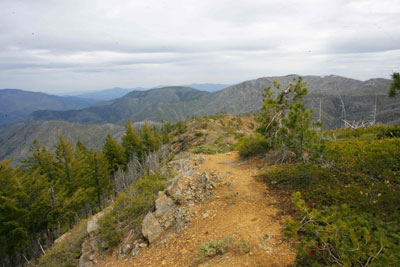
View from the top of Eagle Mountain. |
The mountain trails of the Illinois Valley/Kalmiopsis Wilderness open up earlier than many high-altitude areas in the state. Here’s three trails located about an hour from Grants Pass that make a great place to get that mountain fix during May. More information, details and directions on each hike are provided below. Here’s a link to a video on the hikes, and here’s a photo gallery of the Illinois Valley/Kalmiopsis Wilderness area.o o o oBy Zach Urness of the Daily CourierThe month of May seems to take enjoyment in screwing with mountain hikers and backpacking junkies.The spring weather arrives with bright sunshine and 80-degree temperatures, yet the high-altitude trails remain trapped below a blanket of snow.When the wait becomes too much — when the Cascade Mountains simply take too long to open up — there's one place I travel for an alpine fix to quell early summer jitters.And that place just so happens to be in our own backyard.The Illinois Valley/Kalmiopsis Wilderness has mountain trails that can compete with some of the best in the state. The air might not be as thin, but the reddish-orange landscape that spreads out like a blanket across the lumpy, undulating terrain feels remote enough to be Mars.Evidence of the 2002 Biscuit Fire's toll on the area remains obvious, but that's not always a negative. The fire created panoramic views by thinning vegetation to enhance sight lines. Plus, there's the chance to observe how the land regenerates itself after getting torched.Listed below are three high-elevation hikes open for hiking and located within an hour’s drive of Grants Pass. I've explored all three in the last two weeks and have provided options that are easy, moderate and difficult.May can seem like a frustrating month, but hopefully you'll find something here to quell those cravings until the rest of Oregon’s mountains open for business.Kalmiopsis Rim to Eagle Mountain (moderate/difficult)The views are almost nonstop along this ridgeline hike that traverses the border of the Kalmiopsis Wilderness.Located off Eight Dollar Road, the Kalmiopsis Rim Trail provides easy and more challenging options on a path among craggy peaks.The easiest option is to hike from the trailhead to the giant lump of rock known as Whetstone Butte on a route that runs about 2.3 miles round-trip. The views are excellent and it's an easy scramble to the butte's top.Beyond the Whetstone Butte, the trail drops into a forested section full of burned trees that have fallen across the path.Fire-damaged trails are a major problem in some areas of the Kalmiopsis, and luckily the bad section is brief. Soon the trail hits Eagle Mountain gap, out onto a wide-open ridgeline, and begins climbing. The ascent to Eagle Mountain’s summit is the toughest part of the trail, climbing about 690 feet in 0.8 miles. The difficulty is offset by the views, which peer across a panorama of craggy orange peaks and down upon the Illinois River.The summit is located just off a short spur to the left, where stacked rocks mark the apex. The trail does continue to Chetco Pass, but the path is lousy with downed trees so I turned back and called it a day.Babyfoot Lake (easy)It's tough to imagine anyone interested in local hiking who hasn't explored Babyfoot Lake, but there are a few of you.The trailhead for Babyfoot Lake is a mere 1.4 miles from the Kalmiopsis Rim trailhead along Eight Dollar Mountain Road, making the glacier-carved lake a natural spot for a swim after you've worked up a sweat climbing Eagle Mountain.The hike is short and sweet, dropping 1.2 miles to a green pool that's one of the only lakes in the Kalmiopsis Wilderness.The glacial cirque that holds the lake was badly burned in the Biscuit Fire Still, it’s a pleasant and easy destination.Kerby Peak (difficult)Kerby Peak is a dramatic slab of rock with a hike that requires an uphill test of even the fittest hikers.Located off Deer Creek Road, east of Selma, the Kerby Peak Trail does its best to make climbing 2,700 feet in 3.5 miles manageable with well-graded switchbacks and areas to rest.Oddly enough, climbing Kerby Peak used to be much easier. The old route was just one mile to the summit from the end of White Rabbit Road.“When the (current) Kerby Peak Trail was constructed by the Young Adult Conservation Corps in 1978, the trail attracted little use because the old Rabbit Lake route was so much easier,” wrote Art Bernstein in the book “Hiking Oregon’s Southern Cascades and Siskiyous.”Today, the trail created by the Conservation Corps is the main route, as the old White Rabbit trail has gradually overgrown.The first mile heads uphill to a large rock overlook, then crosses an open mountain pass at the 1.5 mark.The wide-open views stay that way to the summit, passing large craggy boulders and grassy meadows. The summit is large, flat and makes a nice place for lunch (and to catch your breath).The Illinois Valley/Kalmiopsis Wilderness has plenty of trails that appeal to hikers of all stripes, but it’s tough to beat the alpine appeal of Babyfoot Lake, the Kalmiopsis Rim and Kerby Peak.o o o oILLINOIS VALLEY/KALMIOPSIS WILDERNESS HIKESBabyfoot LakeHighlights: Easy hike to lake in glacier-carved cirqueDistance: 2.4 miles round-trip (460 foot elevation loss/gain)Difficulty: EasyKalmiopsis RimHighlights: Epic views of wild, craggy, reddish-orange wilderness mountainsDistance: 2.3 miles round-trip to Whetstone Butte (283 foot elevation gain/loss); 5.5 miles round-trip to Eagle Mountain summit (1,700 foot gain/loss)Difficulty: Easy to Whetstone Butte; strenuous to Eagle Mountain summitKerby PeakHighlights: Difficult but rewarding climb to one of the area’s most prominent peaksDistance: Two miles round-trip to big rock overlook (972 foot elevation gain/loss); 6.4 miles round-trip to summit (2,765 foot gain/loss)Difficulty: Strenuous
| |
|


