|
Fear and loathing in Death Valley National Park
 |
Zach Urness/Daily Courier
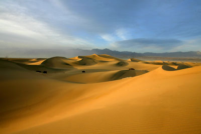
The Mesquite Flat Sand Dunes are located in Death Valley National Park near Stovepipe Wells Village. |
Death Valley National Park is one of the hottest, driest and lowest places on earth. It’s also one of the most beautiful to explore, as I discovered on a trip through its sand dunes and canyons. Here’s a a photo gallery.o o o oBy Zach Urness of the Daily CourierDEATH VALLEY NATIONAL PARK, Calif. — It’s nearly sunset, and I’m hiking across the Mesquite Flat Sand Dunes with a canteen of water and camera slung across my shoulder.There’s a warm, dry wind blowing across the landscape that every 20 minutes or so whips into a frenzy and sends a blast of sand into my face and hair. The day has been pleasant by Death Valley standards — 80 degrees — and the undulating hills of pure, soft sand encased by craggy brown mountains create the illusion of traversing another world, or at least a place very different than the lush Rogue Valley. At the top of the highest dune in sight, I stumble across a shirtless photographer named Rick, who is doing a bizarre sort of dance around his tripod-mounted camera. “I got enough sand in my underwear to bring a beach home with me, dude,” he declares in thick Californian, practically giving himself a wedgie in a vein attempt to liberate the sand. “I’ve been out here all afternoon getting pounded. Just 15 minutes of a mellow sunset. That’s all I want.” A few minutes later, dancing Rick gets his wish. The wind becomes eerily calm, and the twilight sun glows atop creamy waves of a golden brown sand spreading like an ocean toward the cottonwood mountains. Behind me, I can see my trail of footsteps preserved ever-so-briefly in the sand. They lead back to the parking lot and a car that will take me to dinner at a little village named Stovepipe Wells. But for just a moment longer, I look out on the darkening landscape of sand dunes, canyons and dry mountain peaks, and enjoy the magnificent desolation of Death Valley National Park. A land of extremes The sheer variety of ways to meet your maker in Death Valley is impressive. True to it’s motto, “hottest, driest, lowest,” this 156-mile-long trough boasts one of the most inhospitable and extreme environments on earth. The most obvious way to perish in Death Valley is heat. In 2001, the temperature exceeded 100 degrees 153 days in a row. The thermometer hit 134 degrees on July 10, 1913, to register what is now the second hottest temperature recorded (the hottest was 136 degrees, recorded in Libya). Yet another way to find yourself at the Pearly Gates via Death Valley is by falling to your doom. The crashing of tectonic plates, erosion by prehistoric rivers and volcanic activity has crafted sheer cliffs and elevation extremes found in few places. Badwater Basin is the lowest point in North America at 282 feet below sea level. Yet just 15 miles across this desolate salt pan - seemingly straight overhead - are the snow-capped 11,000-foot Panamint mountain range. The most Hollywood of ways to die in the desert is next. Yes, there’s less than two inches of annual rainfall in Death Valley, meaning that drinking water is not easily found. Even if you’re lucky enough to find water, some of it’s undrinkable brine and the rest evaporates in the arid atmosphere at an astonishing rate. Should you need more exciting ways to die, there also are scorpions, black widows, bees, wasps, coyotes, mountain lions and 19 different types of snakes that call Death Valley home. Despite these perils, nearly one million people visit Death Valley each year. And, oddly enough, the No. 1 cause of death actually is single car accidents. Highway 395 revisited There’s no doubt a trip to Death Valley is a big undertaking. But one of the best parts of this 698-mile trip (from Grants Pass, Ore.) is the amazingly beautiful drive down historic Highway 395. For 300 miles south of Reno, Nev., this 1926-created two-lane highway traverses the eastern spine of the Sierra Nevada mountain range and showcases some of the most dramatic scenery in the United States. The road passes Mono Lake — a dazzlingly blue lake three times saltier than the ocean — before passing alongside Yosemite and Kings Canyon national parks, the Mammoth Lakes area and Mount Whitney’s 14,505-foot peak before finally plummeting into the desert near Death Valley. The more impatient of us might be tempted to simply fly down Interstate 5. After driving both routes I found the difference in time negligible, though, requiring between 10 to 13 hours each way, and far more enjoyable along Highway 395. What to do The amazing part of Death Valley is not only the variety of ways to stare death in the eye but the diversity of places to explore. Golden sand dunes, multi-colored canyons, desolate salt flats, mountain peaks, spring wildflowers and, yes, waterfalls can all be reached within this 3 million acres of wilderness. Here are some of the best places to explore in Death Valley, all within range of villages Furnace Creek, Stovepipe Wells and Panamint Springs. Best canyons. The two best canyons I found were Golden Canyon and Fall Canyon. The first is usually crowded, while the second is a longer hike through spectacular narrows and towering, multi-colored walls. Best sand dunes. For sheer accessibility the Mesquite Flat Sand Dunes (right next to Stovepipe Wells) are beautiful and tough to beat. Best mountain hike. My favorite hike in the park begins at Dante’s View, which from 5,475 feet, looks out across Badwater Basin toward the Panamint mountain range. The trail begins on the right side of the the parking area and traverses a ridge line of colorful, rounded mountains. Best waterfall hike. Darwin Falls is fantastic trip if for no other reason than you won’t see this much water anywhere else in Death Valley. The trail runs from absolute desolation into a little green oasis that’s perfect for a hot day. Badwater Basin. You can’t travel all the way to Death Valley and not visit this salty landscape. It’s the lowest point in North America with a uniquely beautiful view. Notes: For all the information you’ll ever need for a trip to Death Valley, visit: http://www.nps.gov/deva. Quick hit: The best and worse of Death Valley National Park “Hottest, Driest, Lowest” Hottest: 112.3 degrees, average temp (June, July August) Driest: Less than 2 inches annual rainfall Lowest: 282 feet below sea level, Badwater Basin
|