|
Castle Crags beckons to climbers
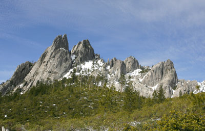 |
Zach Urness/Daily Courier
The Castle Crags rise at the end of the Castle Dome Trail. |
Northern California's Castle Crags State Park features seven spectacular hiking trails, a campground and easy access from Interstate 5. But the real adventure comes from attempting to climb these peaks. Here’s a link to a photo gallery. o o o oBy Zach Urness of the Daily CourierThe idea of exploring Castle Crags State Park arrived purely on a whim this past week, during one of those sunshine-draped February mornings that made any thought of entering the office a loathsome proposition.And so I escaped onto the highway, driving south for two hours along Interstate 5 with no agenda beyond snapping a few pictures of Northern California's famous granite spires. The spectacular heart of the Castle Crags rise from the mountain like a city of white skyscrapers and have been so popular through the years that during the 1920s, pictures of them were used in the campaign to create California’s state park system. With seven hiking trails, easy access from Interstate 5 and a campground featuring 76 sites, this mixture of park and wilderness land has remained a popular destination. But the Crags offer far more than a place for tourists to park their campers. Considered one of the best places for rock climbing in Southern Oregon and Northern California, these white skyscrapers attract multitudes of imitation King Kongs seeking to ascend peaks with names such as Mount Hubris, Six Toe and Castle Dome. “Castle Crags are incredible because of the quality of the rock, the killer scenery and an over the top sense of exposure when climbing,” Grants Pass climber Frank Hannan said. “At every pitch of the climb, there’s an expanding view of the valley around. You can see Mount Shasta just across the way, and the rest of the wilderness is just breathtaking.” I arrived at the Vista Point Trailhead around 11 a.m. this past Thursday and began hiking uphill through a sweet-smelling forest of incense cedars and dogwood trees. After 2.7 miles, I reached the heart of the Crags and was presented with a serious dilemma. I've sworn to myself — and to my parents and girlfriend — that I'd stop climbing potentially dangerous peaks when I'm hiking alone. Solo climbing is not wise, if for no other reason than you need someone to bring your mangled corpse back to civilization for a proper burial. But the truth is that I've had an awful time keeping this promise. There’s a magnetic force within massive rock structures such as Castle Dome — the monolithic king of the Castle Crags — that turns otherwise rational people into risk-taking buffoons. Which is exactly how I found myself zig-zagging up the steep wall of Castle Dome’s first section, following a prominent quartz vein in the salt-and-pepper rock. The granite seemed to grip to my boots like Velcro as I tightroped along a narrow porch to the dome's east side, where the ground drops a few thousand feet down sheer cliffs. From that point I crammed myself into a dark crevasse known as “the gully” and crawled up through the mountain's large intestine, until I emerged at the wide-open wall below the summit. The first three sections — the ramp, narrow porch and gully — were all easy enough, at least for those who don’t mind heights. All of that was about to change. The final pitch of Castle Dome’s regular route is graded Class 4 by the Yosemite Decimal System, which designates a steepness and exposure where using rope is recommended because falling could be fatal. The knowledge that any slight problem — a crumbling rock or sweaty palms — could mean a deadly fall changes the way you climb. I could feel the sandpaper texture of rock below my fingertips, and each upward step wrapped a paralyzing rush of fear around my chest. When I peered over my shoulder, the jagged teeth of the Trinity Alps spread across the cobalt sky in a sweeping panorama. Inch-by-inch, I pulled myself onto a wide, 4,966-foot summit so rounded it felt as though I was standing on the apex of a pinhead. The salt-and-pepper rock was washed in yellow sunlight and a few trees actually grew up between the cracks. To the northeast, the white face of Mount Shasta seemed to rise up and look me in the eye. The stay was short, however, since my paranoia about the descent overwhelmed any joy I could derive from the summit. The climb back down was very, very slow. And by the time I reached the bottom, the nervous energy from the climb seemed to fall out of me all at once, as I dropped down into a heap, laying down in the sunlight for a solid 20 minutes. Later that day I stopped at Indian Springs, a small shower of water that flows year-round from the mossy granite. I stuck my head below the springs and felt the cool water run across my neck. Somehow, the water felt like a blessing that absolved me from the sin of solo climbing. O O O CASTLE CRAGS STATE PARK TRAILS Indian Creek Nature Trail (Easy, 1 mile loop, 150 foot elevation gain): This 1 mile loop hike starts near the flag pole at the Ranger Station. A trail guide is available at the box at the start of the trail. This short, but delightful trail crosses cascading Indian Creek twice over wood and stone bridges and offers distant views of the Castle Crags. Wildflower viewing is good in spring. Root Creek Trail (Easy, 2 miles round-trip, 120 foot elevation gain): This gentle 1 mile hike that begins at Vista Point is a peaceful walk through the woods and offers a reward at the end: tumbling, beautiful Root Creek. The entire trail is shaded and offers opportunities to view some of the park’s many varieties of orchids during spring and early summer. River Trail (Easy, 3 miles round-trip, 50 foot elevation gain): This gentle hike, which begins at Riverside picnic area is a must for river enthusiasts. The trail closely follows the Upper Sacramento River and crosses two year-round creeks. The hike offers a chance to cross the river on a suspension bridge and spring wildflowers and autumn colors are outstanding. Campers may access this trail from near site #13. Flume/PCT/Bob’s Hat Loop (Moderate, 15 miles round-trip, 850 elevation gain): This long loop hike starts at the Indian Creek Nature Trail. This hike is a good choice in winter when higher trails are snow covered, and in spring when seasonal creeks cross the trail and wildflowers are blooming. After .5 miles on Indian Creek Trail, take the Flume Trail junction to the Pacific Crest Trail. Flume Trail follows the course of a flume and ditch water system that served the town of Castle. Stay on Flume Trail to the second PCT junction for rewarding views of Castle Crags and a gentler ascent to the PCT. Turn right on the PCT and follow this level trail to Bob’s Hat Trail which will allow you to descend back to your starting point. A map is a must for this hike. Dog/PCT to Burstarse Falls (Moderate, 4.6 miles round-trip, 720 foot elevation gain): This hike, which begins three miles west on Castle Creek Road, is on US Forest Service property adjacent to the State Park and allows dogs. Follow steep, exposed Dog Trail .5 miles to the PCT junction and turn left. When the PCT crosses signed Burstarse Creek, hike upstream past a small falls and another cascade to a 40 foot waterfall. These falls go dry after early summer. Crags Trail to Castle Dome (Strenuous, 5.4 miles round-trip, 2,200 foot elevation gain): The classic trail of the Castle Crags State Park, which begins at Vista Point is uphill almost the entire way to the park’s best views of the Crags. The first 1.3 miles passes through dense forest before emerging to excellent views. Just beyond 1.5 miles, a spur trail offers a five minute walk to Indian Spring which flows-year round out of the granite rock and surrounded by ferns. The last portion the hike toward Castle Dome is steep and rocky, following markers in the trail, but the views are worth the effort. Experienced rock climbers may choose to ascend 500 feet at Castle Dome at the trail’s end. O O O GEOLOGY According to Eugene outdoors writer William L. Sullivan — author of “100 Hikes in Southern Oregon” — the Castle Crags basically rose up through the depths of the planet. For several hundred million years the North American continent has been crushing its way over the Pacific plate. In the process, the descending seafloor drags down a lot of sand and mud with it. When this relatively light sedimentary meterial gets deep enough it melts to form granite. Then it bubbles up through the continent toward the surface. Castle Dome, like Yosemite Valley’s Half Dome, is the rounded top of a granite bubble that cooled underground and was later exposed by erosion. The area also has had lots of glacial activity that helped create several lakes in the Castle Crags Wilderness including Gray Rock Lake. Timber Lake and Little Castle Lake. HISTORY For thousands of years, the Indians living around the base of Castle Crags regarded this formation with awe and superstition, rarely if ever venturing up into its heights. After a few years of gold rush in the 1850's, the relationship between miners and Indians strained to a breaking point. The result was the 1855 Battle of Castle Crags, which marked the beginning of the long and drawn-out Modoc War. The primary location of this battle was at the very northwest end of the Crags between what is now known as Battle Rock and Castle Lake. By 1886, construction of the Southern Pacific Railroad through the Sacramento River canyon was completed, resulting in extensive lumber and mining operations. Chromium mines were operating as late as the 1950's in one part of the Castle Crags. Today none are operational, and most mines have been swallowed up by the re-emerging wilderness. In 1933, concerned citizens succeeded in acquiring much of the land that became the Castle Crags State Park. Numerous resorts and hotels also flourished throughout the late 1800's and early 1900's; many were built around the mineral springs discovered by the miners. Castle Rock Mineral Water won numerous awards regionally and statewide. Although most of these resorts no longer exist, a few of these historic buildings can still be found in the Castella area. For more information, check out GORP.com. PLANTS AND ANIMALS Trees of the area range from mostly live oak in the lower elevations to red fir, Jeffery pine and weeping spruce (also known as Brewer spruce) near the Crags summit. Mixed conifer forests include western yew, Port-Orford cedar, incense cedar, sugar pine, ponderosa pine, Douglas fir, white fir and lodgepole pine. Broadleaf trees such as bigleaf maple, vine maple, black oak and Pacific dogwood can be found in the area. Poison oak is also common at lower elevations. Shrubs include azalea, ledum, and tanoak in the moist areas, while the dry slopes are dominated by greenleaf manzanita, pinemat manzanita, wedge-leaf ceanothus, whitethorn, snowbrush and deerbrush. The area contains over 300 varieties of herbaceous wildflowers. Indian rhubarb, tiger lily, pitcher plant and yellow monkey flower can be found in the moist areas. Cycladenia, yarrow, aster and eriogonum are found on dryer sites. The Castle Crags hairbell (Campanula shetleri) is a flower found only in the Crags. Birds of the wilderness include jays, ravens, warblers and other common woodland species. Hawks, golden eagles and peregrine falcons are also known to inhabit this area. Reptiles common to the area are lizards and rattlesnakes. Although the local variety of rattlesnake (Crotalis viridis) is neither as poisonous or aggressive as the southern variety, caution is still advised. Mammals include the common ground squirrel, gray squirrel, coyote, mule deer, bobcat, mountain lion and black bear. Martins and fishers are rare but occasionally seen. For more information, check out GORP.com.
|