|
Funky history and great views at Mount Bolivar
 |
Zach Urness/Daily Courier
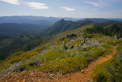
Near the summit of Mount Bolivar. |
The drive to Mount Bolivar Trailhead from Grants Pass might take a while, but those who make the trip are rewarded with a easy hike that features fantastic views of the Wild Rogue Wilderness, along with a funky bit of history that connects Southern Oregon with Venezuela. o o o oBy Zach Urness of the Daily CourierThe drive from Grants Pass to the Mount Bolivar Trailhead has a way of turning even mature adults into 6-year-old children.Are we there yet?No, seriously.Are. We. There. Yet?Despite the fact that Mount Bolivar is just 35 miles from Grants Pass as the crow flies, the drive to this remote trailhead requires a whopping two and half hours.Time seems to melt away on the winding, car-sick-inducing curves of Forest Service and Bureau of Land Management roads.Once you reach the trail and begin hiking, though, the seemingly endless drive finally becomes worthwhile.Mount Bolivar is the highest point in the Wild Rogue Wilderness, a place where the Siskiyou Mountains collide with the Coastal Range and the views showcase valleys sliced by the trio of streams — the Rogue, Coquille and Cow Creek.But the most interesting aspect of this fairly easy hike — which climbs 1.4 miles and 1,160 feet — is the oddball monument that you’ll find at the top.At the 4,319-foot summit, there’s a small bronze plaque nestled between the foundation of an old fire lookout. That’s strange enough, but look closer at the plaque and you’ll see something even more interesting.It reads:“The United States was the first to teach us the path to independence”- Simon Bolivar, Jamaica, 1815The plaque also points out that the monument was a gift from Venezuela to the people of Oregon, dated 1984.So ... what exactly is a monument quoting a Latin American hero doing in the wilds of Southern Oregon?The story begins with a Coos County surveyor named Simon Bolivar Cathcart, who was born in Indiana and moved west with the first wave of white settlers.He served in the first Oregon Calvary and during a career that also included horse and cattle trading, explored many local mountains.Around 1900 he dubbed the highest point in Coos County as Mount Bolivar — but he wasn’t naming the mountain for himself (which would have been just a tad egomaniacal).The name was instead meant as a tribute to the Venezuelan military and political leader Simon Bolivar, who helped free much of Latin American from Spanish rule.How the monument wound up on a summit in the middle of the Southern Oregon is tougher to pin down.The Venezuelan government apparently appreciated the gesture, and there are newspaper accounts of the plaque being placed there Sept. 22, 1984, as a way to “commemorate the bond between Venezuela and the United States.”Not much else can be found.At any rate, it’s an odd little tribute within the backdrop of rugged mountains that spread out in every direction.The summit area makes a good place for lunch, and as you enjoy the views it’s interesting to imagine what Simon Bolivar (the liberator, not the surveyor) would have thought about this mountain being named for him.Even though he died before Oregon became a state, I think he would have enjoyed it. Bolivar was all about independence, a spirit that’s certainly encapsulated by the Wild Rogue Wilderness.The drive from Grants Pass to Mount Bolivar seems to take forever. But I’d venture to say there’s few mountain hikes that combine stunning vistas with odes to Latin American heroes.o o o oMount Bolivar TrailLocation: Wild Rogue WildernessAdventure: Day hikeEffort: Easy/moderateTrail distance: 2.8 milesElevation gain: 1,160 feetDirections:From Glendale: Head west 3 miles into Glendale. Opposite a small gas station (that no longer is operating), turn right on Brown Street, which becomes Reuben Road. After 12.3 miles, veer left at a large brown signboard. Take this paved side road past the turnoff for Marial and continue to a six-way junction. Follow Kelsey Mule Road 32-8-31 for about 4 more miles to a trailhead on the left.From Grave Creek boat landing: Turn left just over the Grave Creek bridge and head up the mountain on 34-8-1 (gravel) for 15 miles. The road is very narrow and winding for the 3 miles between Whiskey Creek Road and Sawmill Gap. At mile 15.1, the road merges with the upper end of Whiskey Creek Road and becomes 32-7-19.3. At mile 15.6, pick up 32-8-31, a one-lane blacktop road from Glendale. Turn left, toward Powers, and continue 13.8 miles continue to a six-way junction. Follow Kelsey Mule Road 32-8-31 for about 4 more miles to a trailhead on the left.
| |
|